


This article is taken from PN Review 274, Volume 50 Number 2, November - December 2023.
Pictures from a LibraryA Multi-Centred Globe: Readings of the Desceliers Map
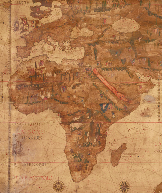
Caption: Detail of the African continent, French Manuscript 1*, 1546
(© University of Manchester 2023)
Fashioned from four sheets of parchment, this mammoth map of the world measures 4 feet 9 inches high by 8 feet 3 inches wide. It was made by the Norman cartographer Pierre Desceliers for King Henry II of France in 1546, the year prior to his ascension to the throne. The gloop of a dirty brown glaze applied to its surface at some stage suppresses the chromatic radiance of its paintings underneath. Yet through this obscuring slime continents and oceans emerge, their shapes sometimes familiar, otherwise strange, teeming with life forms of fauna, flora, and myriad versions of human beings, fantastical and real. As the sum of sixteenth-century European geographical knowledge, we are shown a brave new world with seas singing in French and settlements clustering round coastlines, their names rendered in Portuguese and their hinterlands largely devoid of detailed physical features.
The type of cartographic projection used by Desceliers places a disproportionately large European landmass at its heart and so seems to stitch assumptions of its inflated position in the world into its actual fabric. Meanwhile, the more than eleven million square miles of Africa, the planet’s ‘oldest and most diverse continent’ (Binyavanga Wainaina), is diminished in size to accommodate the distortion, obliterating a multiplicity of centres in the process. At the time of this map’s making Africa was composed of vast ancient kingdoms (Dipo Faloyin) ...
The page you have requested is restricted to subscribers only. Please enter your username and password and click on 'Continue'.
If you have forgotten your username and password, please enter the email address you used when you joined. Your login details will then be emailed to the address specified.
If you are not a subscriber and would like to enjoy the 282 issues containing over 11,400 poems, articles, reports, interviews and reviews, why not subscribe to the website today?
